Curral Velho (Boa Vista)
Curral Velho ist eine Wüstung im Süden der Insel Boa Vista im atlantischen Inselstaat Kap Verde. Das Dorf lag an der Südküste, ca. 25 km südöstlich der Inselhauptstadt Sal Rei. Das umgebende Gebiet ist heute ein Schutzgebiet (Paisagem Protegida de Curral Velho) mit einer Fläche von 16,35 km².[1][2] Die nahegelegene Insel Ilhéu de Curral Velho und die angrenzende Küste ist ein Important Bird Area.[3] Die Ruinen von Curral Velho, São Domingos und Prazeres, Beispiele traditioneller kapverdischer Architektur sind in einem schlechten Erhaltungszustand.[1]
Galerie
-
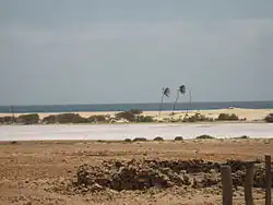
 Curral Velho von Norden
 -
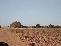
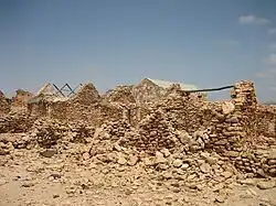 Die Ruinen von Curral Velho
 -
_-_panoramio.jpg) Tuareg resort
Tuareg resort
Einzelnachweise
- ↑ a b Protected areas in the island of Boa Vista. Municipality of Boa Vista. municipiodaboavista.com März 2013. Archivlink
- ↑ Resolução nº 36/2016 Estratégia e Plano Nacional de Negócios das Áreas Protegidas. extwprlegs1.fao.org Archivlink
- ↑ Ilhéu de Curral Velho and adjacent coastal area. In: Important Bird Areas factsheet. BirdLife International, 2018, abgerufen am 3. August 2018 (englisch).
Koordinaten: 15° 59′ 31,2″ N, 22° 47′ 38,4″ W